River Intelligence
The only fishing app that takes rivers seriously.

Why Rivers Need Their Own Intelligence System
Lakes change slowly. Water temperature shifts over days or weeks.
Rivers change HOURLY. A rainstorm 50 miles upstream can change everything about where fish hold.
That's why Get Hooked! built an entire intelligence system around rivers.
Live River Flow Data ONLY APP
Real-time USGS monitoring data, right on the map. No other fishing app does this.
- Real-time USGS flow data — cubic feet per second (CFS) updated continuously
- Flow as percentile vs. historical norm — not just raw CFS, but what the number actually means for this river right now
- Color-coded at a glance: GREEN = normal, YELLOW = rising, RED = blown out
- Historical percentile calculations — p10, p25, p50, p75, p90 so you know exactly where current flow sits in the historical range
- Water temperature when a sensor is available at the station
- Environment Canada integration for Canadian rivers
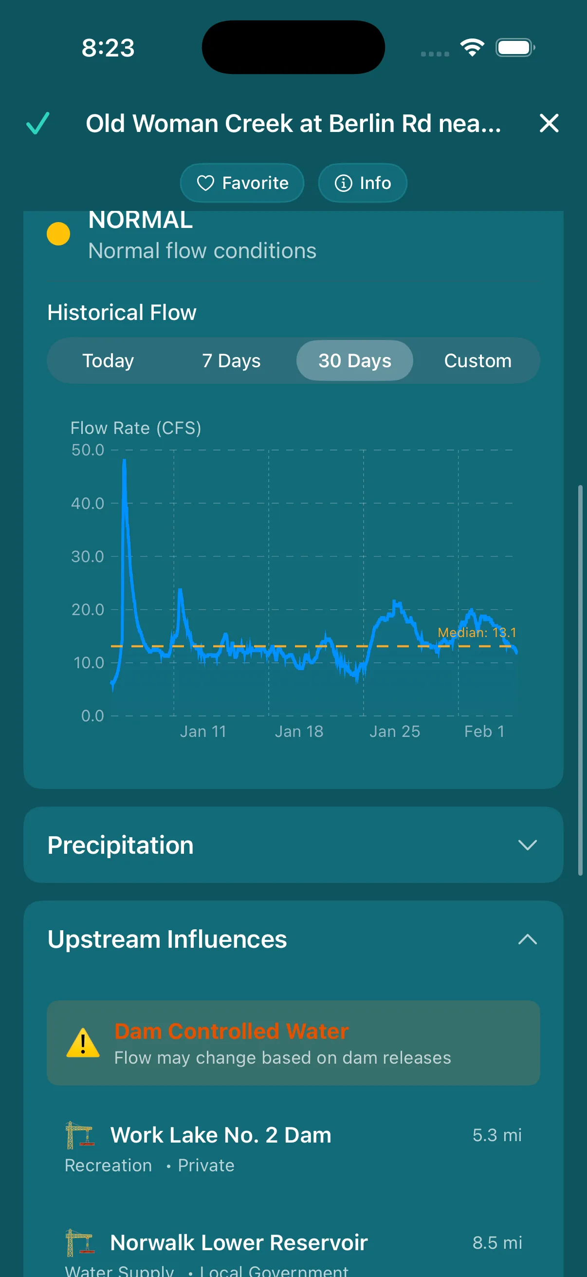
River flow detail with historical percentiles
Custom Flow Alerts
Know the moment your river hits the right conditions.
- Favorite unlimited rivers across the entire US and Canada
- Set custom CFS thresholds — upper and lower bounds for your ideal fishing flow
- Get notified when conditions are right — push alerts when flow enters your target range
Your favorite steelhead river hits the right flow? You'll know before anyone else.
River Explorer NEW
14,000+ US rivers with full watershed visualization.
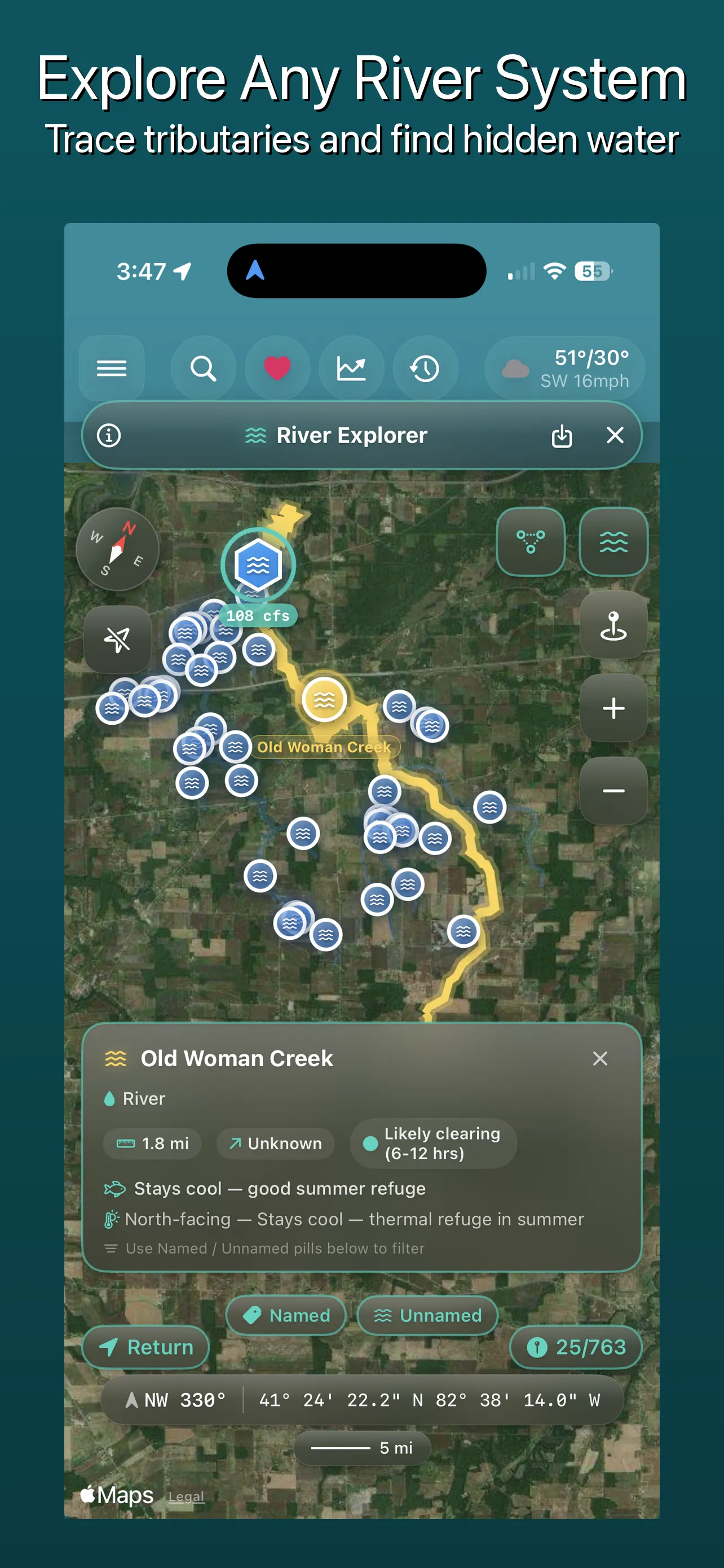
Upstream tributary network on the map
- Tap any waterway to draw its entire upstream network on the map
- Line thickness = stream order (Strahler classification) — see at a glance which tributaries carry the most water
- Tributary pills at midpoints — tap any tributary for detailed fishing intelligence
Tributary Intelligence
Every tributary tells a story. Get Hooked! reads it for you.
Gradient Class
Steep: Smallmouth and trout water. Fast current, rocky substrate, oxygenated pools.
Medium: Mixed fishery. Transitional water with diverse habitat.
Flat: Bass and panfish water. Slower current, deeper pools, softer substrate.
Thermal Character
North-facing: Stays cool longer into summer. Refuge water when main river warms up. Trout and smallmouth hold here in July and August.
South-facing: Warms early in spring. First tributaries to activate after winter. Early-season hotspots.
Recovery Time
How quickly the tributary clears after rain. Calculated from stream length and watershed characteristics.
Short tributaries: Clear in 6-12 hours. Fish the evening after morning rain.
Long tributaries: May take 2-4 days. Plan accordingly.
Species Hints
Derived from gradient, aspect, and stream order. The app cross-references physical characteristics to suggest what species likely inhabit each tributary.
Steep + cold + high-order = trout water. Flat + warm + low-order = bass and panfish. The math does the scouting for you.
Waterway Detail Sheets
Tap any waterway for a deep-dive across 6 tabs of intelligence.
Info
Watershed profile, Big Fish Potential rating, dam fields, and directions. Everything you need to know before you go.
Forecast
Adjustable radius slider (saved per-waterway), catch count, and your personalized AI forecast for this water.
Flow
Live flow status hero card, custom CFS alert slider, and a time-series chart showing the P25-P75 historical band so you can see where current flow sits.
Temperature
Water temperature hero with optimal species ranges, time-series chart, and anomaly detection vs. historical averages.
Precipitation
3-column precipitation summary with bar chart visualization. See what rain is doing upstream and downstream.
Network
Named tributaries with angler-friendly stream order labels and expandable tributary cards showing gradient, thermal character, and recovery time.
The Data Behind It
River Intelligence is built on authoritative federal datasets.
NHDPlus HR flowlines — the most detailed hydrographic dataset in the United States
Real-time monitoring stations — live flow, gage height, and water temperature across the US
Environment Canada rivers — real-time hydrometric data for Canadian waterways
Dams with National Inventory of Dams data — location, type, height, and storage capacity
Dam release schedules — federal dams link directly to release schedule pages so you know what's coming downstream
Named US rivers mapped with full upstream watershed visualization in the River Explorer
Ready to fish rivers smarter?
Live flow data, custom alerts, and tributary intelligence — all in one app.
© 2026 Hooked on Yutz. Get Hooked! is a trademark of Hooked on Yutz.